
1. Introduction
In recent years, the adoption of floating solar photovoltaic (PV) projects has been on the rise due to their numerous advantages. These projects utilize the surface area of water bodies such as dams to install solar panels, thereby maximizing energy generation. However, before the installation of floating solar PV panels, a comprehensive bathymetry survey of the dam's reservoir is crucial. This article explores the procedure for conducting a bathymetry survey using both single beam and multi-beam echosounders for floating solar PV projects.
2. Understanding Bathymetry Survey
Bathymetry survey is the process of measuring and mapping the underwater topography, including the depth and contours of water bodies. It provides valuable information about the reservoir's bed, enabling accurate planning and design of floating solar PV systems. By understanding the reservoir's bathymetry, engineers can determine the most suitable locations for installing solar panels and assess any potential challenges or risks.
3. Importance of Bathymetry Survey for Floating Solar Photovoltaic Projects
Accurate bathymetry survey is essential for the successful implementation of floating solar PV projects. Here are some key reasons why it is crucial:
Optimal panel placement: By mapping the reservoir's bathymetry, engineers can identify areas with appropriate water depth and bottom conditions for installing floating solar PV panels. This information ensures optimal panel placement, maximizing energy production.
Structural integrity: A thorough survey helps identify any underwater obstacles, such as rocks, submerged structures, or uneven terrain. This information is crucial for designing sturdy anchoring systems that can withstand the dynamic forces acting on the floating solar PV arrays.
Efficient cabling: Understanding the bathymetry allows engineers to plan the routing of electrical cables for connecting the floating solar PV panels to the shore. By avoiding obstacles and selecting the most efficient paths, cable installation becomes more streamlined.
Maintenance planning: Detailed bathymetric data assists in planning maintenance activities for the floating solar PV systems. It helps identify potential sedimentation areas, erosion hotspots, or areas prone to debris accumulation, enabling proactive maintenance measures.
4. Survey Equipment and Tools
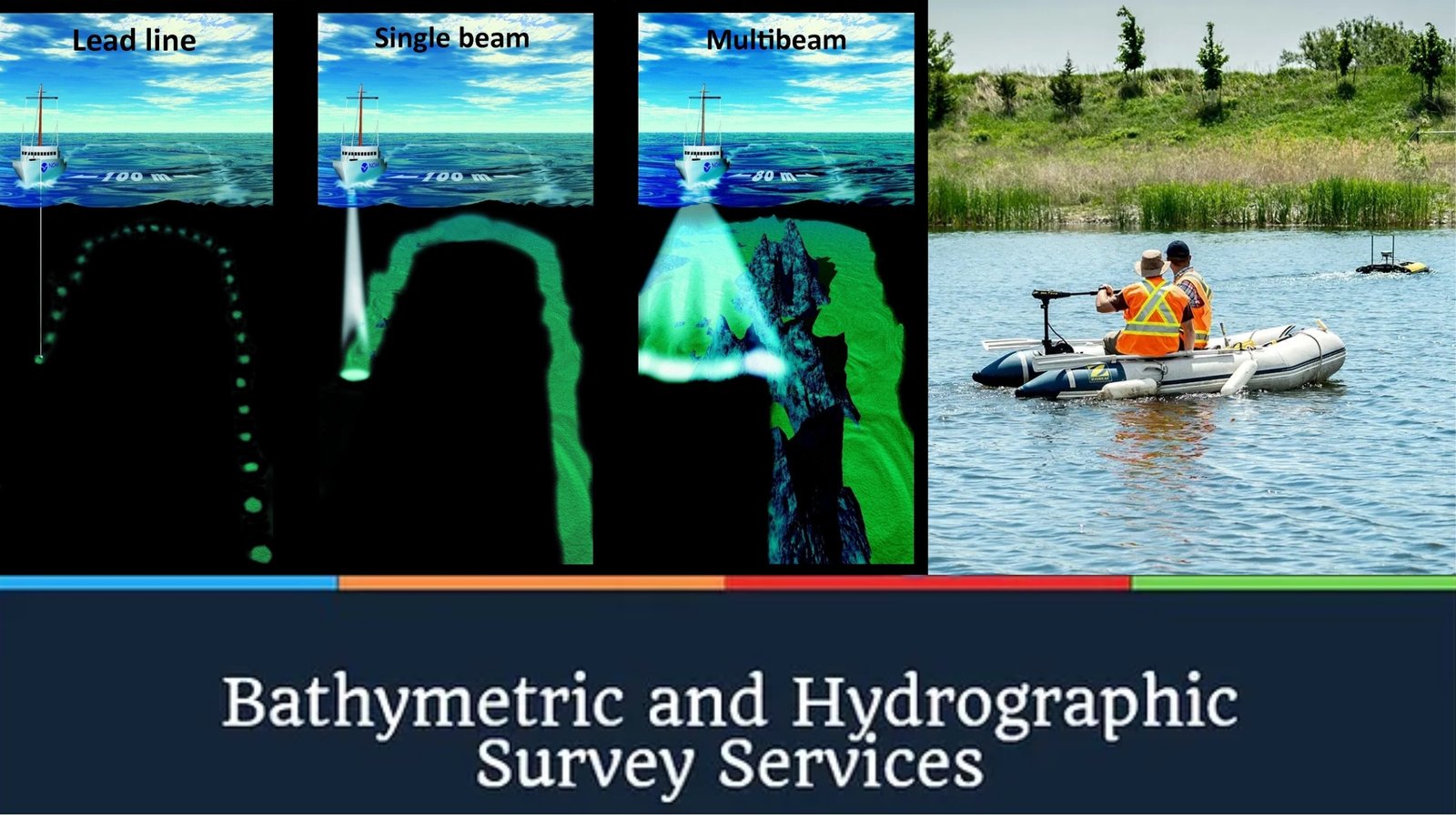
To conduct a bathymetry survey, both single beam and multi-beam echosounders are commonly used. Single beam echosounders emit a single acoustic pulse downward and measure the time it takes for the echo to return, determining the water depth. On the other hand, multi-beam echosounders utilize an array of beams to capture a wider swath of the reservoir's bathymetry, providing higher-resolution data.
Additional equipment and tools used in the survey may include GPS receivers for precise positioning, survey boats or vessels, sound velocity profilers to measure the speed of sound in water, and data loggers to record and store the survey data.
5. Preparatory Steps for the Survey
Before conducting the bathymetry survey, certain preparatory steps are necessary to ensure the accuracy and efficiency of the process. These steps may include:
Site reconnaissance: Visit the dam site to assess the accessibility, prevailing weather conditions, and any potential safety hazards.
Survey planning: Determine the survey area boundaries, considering the extent of the floating solar PV project. Establish a grid system for systematic data collection.
Calibration: Calibrate the echosounders and other survey equipment to ensure accurate measurements.
Safety measures: Implement safety protocols, including the use of personal protective equipment and adherence to boating and diving guidelines.
6. Conducting the Bathymetry Survey
The actual bathymetry survey involves the following steps:
Deploying the survey boat: Launch the survey boat equipped with the echosounder system, GPS receiver, and other necessary equipment.
Data collection: Navigate the boat across the reservoir in a pre-determined grid pattern, ensuring complete coverage of the survey area. Record the depth readings and corresponding GPS coordinates.
Quality control: Regularly monitor the survey data for anomalies or inconsistencies. Conduct spot checks to verify the accuracy of the collected data.
Post-processing: Process the collected survey data using specialized software to create bathymetric maps and contour lines. Perform data corrections and filtering to enhance the accuracy of the final results.
7. Data Analysis and Interpretation
Once the bathymetry survey data has been processed, it can be analyzed and interpreted for further decision-making. Engineers and project managers can:
Identify suitable locations: Analyze the bathymetric maps to determine the most suitable areas for installing the floating solar PV panels, considering factors such as water depth, bottom conditions, and accessibility.
Evaluate risks: Identify any potential risks or challenges based on the survey data, such as underwater obstacles, variable sedimentation levels, or erosive areas. Develop mitigation strategies to address these issues.
Optimize design: Utilize the bathymetric data to optimize the design of the floating solar PV arrays, anchoring systems, and cable routing. Ensure structural integrity and efficient energy production.
8. Challenges and Solutions
Conducting a bathymetry survey for a dam reservoir can present various challenges, including:
Sedimentation: Sedimentation can affect the accuracy of depth measurements. Implementing regular surveys and considering sedimentation patterns can help mitigate this challenge.
Underwater obstructions: Underwater obstacles, such as rocks or submerged structures, can impede the installation of floating solar PV panels. Accurate mapping and proper design can help overcome these challenges.
Water turbidity: High turbidity can hinder acoustic signals and impact data quality. Using appropriate signal processing techniques and selecting suitable survey windows can help mitigate this challenge.
Safety considerations: Conducting surveys in water bodies requires adherence to safety protocols to ensure the well-being of the survey team. Proper training, equipment, and risk assessments are crucial.
9. Conclusion
A thorough bathymetry survey is a critical step in the successful implementation of floating solar PV projects on dam reservoirs. By accurately mapping the underwater topography, engineers can optimize the panel placement, ensure structural integrity, plan efficient cabling, and proactively address maintenance needs. The use of both single beam and multi-beam echosounders provides valuable data for analysis and decision-making. With careful planning, execution, and data interpretation, bathymetry surveys contribute to the long-term success of floating solar photovoltaic projects.
Frequently Asked Questions -
1. How long does a bathymetry survey typically take?
The duration of a bathymetry survey depends on various factors, including the size of the survey area, the equipment used, and the complexity of the reservoir's bathymetry. Typically, a survey can range from a few days to several weeks.
2. Can a bathymetry survey be conducted during adverse weather conditions?
Ideally, bathymetry surveys should be conducted during favorable weather conditions to ensure the safety of the survey team and the accuracy of the measurements. Adverse weather conditions, such as storms or heavy rainfall, can affect data quality and pose risks to the survey boat and crew.
3. How often should bathymetry surveys be conducted for floating solar PV projects?
Bathymetry surveys should be conducted at regular intervals to monitor any changes in the reservoir's bathymetry. The frequency of surveys may vary depending on factors such as sedimentation rates, erosion patterns, or the need for maintenance planning. Consultation with experts and project-specific considerations can help determine the appropriate survey frequency.
4. Can bathymetry survey data be used for other purposes apart from floating solar PV projects?
Yes, bathymetry survey data has broader applications beyond floating solar PV projects. It is valuable for various industries, including hydroelectric power generation, environmental studies, navigation, and marine habitat mapping.
5. Is it possible to combine bathymetry survey data with other geospatial data for comprehensive analysis?
Absolutely! Combining bathymetry survey data with other geospatial data, such as aerial imagery or topographic maps, enhances the overall understanding of the reservoir's characteristics. This integrated analysis can provide valuable insights for project planning, environmental assessments, and resource management.